 No matter what sort of voyage a vessel is undertaking, it is likely that it will come across the phenomenon of the Tidal Race. This is a natural occurrence, taking place as a fast moving tide passes through a constriction. The result of this can be waves, eddies, overfalls and hazardous currents. The constriction can be in the form of a passage where the sides are narrow, as in the Gulf of Corryvrechan, or the Saltstraumen maelstrom, or an underwater obstruction (reef or rising seabed), as in the Portland Race. Some sort of race can be expected off virtually any headland when the tide is running. Some races are relatively minor but most require care. If a vessel keeps at least 5 miles off shore, it is usually outside the danger area, but on the other hand, some headlands can be passed very close in calm conditions, by experienced sailors and those with local knowledge.
Dangers
When a vessel hits a tidal race its position may be changing too fast for conventional navigational techniques, so great care must be taken:-
Local back eddies may develop, as can be experienced in the Needles Channel at the west end of the Solent.
Overfalls often occur within a tidal race, where the tide flows over a shallow patch on the seabed, causing rough water on the down-tide side of the obstruction.
Large whirlpools develop when a particularly strong local current flows past an island or headland. They are a large, powerful eddies, the centres of which are noticeably lower than sea level. These may be extremely hazardous to navigation, as in the case of the Skookumchuck Narrows in British Columbia, where tides can travel at more than 17 knots.
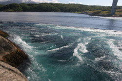
Some notable tidal races
The Pentland Firth has some of the fastest tides in the world, having had a tide of 16 knots measured, west of Pentland Skerries. In this area powerful tidal races and overfalls can be found, occuring at different stages of the tide. They include:-
- “The Merry Men of Mey”- Off St John’s point. The tides in this area can exceed 10 knots, the worst part being over a sand wave field about 3½ miles (5.6 km) west of Stroma. The race is particularly strong in a westerly tide.
- “The Swelkie” - The name comes from an Old Norse word, Svalga, meaning "the swallower". The races form at the north and south ends of Stroma and Swona. They have overfalls and whirlpools and in especially bad weather very large swell waves can form which can cause even large boats to be pushed off course. There is a whirlpool of the same name, which appears in a Viking legend. It was supposedly caused by a sea-witch as she turned her mill wheels to grind the salt which she used to make the sea salty.
- The “Duncansby Race” - Off Ness of Duncansby. The race is particularly strong and dangerous when there is bad weather approaching in the opposite direction, but there is a temporary respite at the turn of the tide. During the east-going stream a race forms off Ness of Huna, which can be particularly violent in an easterly or south-easterly gale.
- The “Liddel Eddy” - Between South Ronaldsay and Muckle Skerry. There is another race which sometimes forms off Old Head in the SE of South Ronaldsay.
The Hag of Corryvreckan (from the Gaelic name Coire Bhreacain) has a fearsome reputation. It forms in a narrow channel between the islands of Jura and Scarba, in Scotland. When the flood tide enters the channel, it speeds up to 8.5 knots, also meeting a variety of seabed features, including a deep hole and a high pinnacle. These combine to create whirlpools and standing waves. The Corryvreckan whirlpool is the 3rd largest in the world. Waves of over 9m have been recorded and it is said that the turbulence can be heard 16 km away.
The Gray Dog is a tidal race between the Islands of Lunga and Scarba. During a high spring tide, an impressive "waterfall" effect is produced which changes direction as the tide turns.
The Portland Race occurs to the south of Portland Bill. Portland Ledge (the Shambles) is an underwater ledge of Portland Stone which extends into the English Channel at a place where the depth of the channel is 20 to 40 metres (about 10 to 20 fathoms). Tidal flow is disrupted by the ledge and the current only stops for brief periods during the tidal cycle. It can reach 4 metres per second (8 knots).
The Needles Channel is between the Dorset coast and the rock formation known as the Needles, the famous five chalk stacks that protrude into the sea from the Isle of Wight. Just off the end of the Needles formation is the Shingles, a shifting shoal of pebbles just below the waves. The Shingles is approximately three miles in length and many ships have come to grief there. On an ebb tide there is a back eddy running close along the shore of Hurst Spit, at the end of which is a shallow area extending off shore, which should be navigated with caution.
The Alderney Race and the Swinge are well known for their dangers and great care should be taken approaching Braye Harbour. Strong tidal streams (up to 9 knots in the Swinge and 11 knots in the Race) can create dangerous overfalls, especially with the wind over tide. Slack water is the safest time to sail in this area, keeping to the south side of the Swinge, close to Corbet Rock, but if you miss slack water, a safe anchorage can be found in Longy Bay while you wait for a fair tide. To add to the dangers, Alderney has many rocks around it. My husband remembers trying to head for Braye but being swept disconcertingly down the race towards Guernsey. He kept taking frequent bearings on the lighthouse, to ensure the boat was maintaining a constant bearing, until they eventually picked up a back eddy, which helped them sweep safely into Braye. These areas also have features known as up-wellings, flat circles of water surging up from below. The first time I saw them in the Swinge, I thought they had a look of evil and malevolence about them.
The Casquettes can also cause danger when heading to Braye from the West. On one occasion we were using auto pilot when the tidal surge pushed the vessel northward, causing the boat to swing straight for the rocks. It was a hairy moment, and it was difficult to believe that the autopilot knew what it was doing. It was correct, and we cleared the rocks safely. Maybe with hindsight it would have been better to set a course with a little more clearance.
On the north-west corner of Brittany, there is a line of small islands jutting out into the Atlantic towards the Ile d’Ouessant (or Ushant as the Brits call it). At the inshore end is the Chenal du Four. Although it is a genuine through route, it often provides strong tides and poor visability, not a nice combination, especially when you take into consideration the added dangers of wide reefs, isolated rock heads and deep gullies, which can cause powerful and hazardous currents. Although pilotage can be tricky, the fast tidal stream can provide a well needed boost if the wind dies away.
The world record for a current in the sea is held by the Saltstraumen near Bodø, in Norway. As the tide in the Skerstadfjord ebbs and flows, the water has to squeeze through a channel about 150 metres wide. Up to 400 million tonnes forces its way through the channel every six hours. The average top speed of the water is 7-9 knots, with peak flow estimated at 20 knots. When the current is strong large whirlpools are generated which can be 10 to 15 metres across.
Skookumchuck Narrows, claimed to be one of the fastest tidal rapids in the world, is found at the entrance of Sechelt Inlet on British Columbia’s Sunshine Coast in Canada. Before it widens into Sechelt Inlet, all of its tidal flow, and that of Salmon Inlet and Narrows Inlet, passes through the Sechelt Rapids. At peak flows, whitecaps and whirlpools form, even in calm weather and as the water is forced through the narrows, the difference in water levels on either side of the rapids can exceed 2 metres (6.6 ft) in height and current speeds can exceed 16 knots.
The largest tidal whirlpool in North America is the Old Sow, off Deer Island in the Bay of Fundy. The area also has the world's largest tidal range, from 3.5m along the SW shore of Nova Scotia, to 16m in the Minas Basin at the head of the bay.
The tidal races around Cape Horn caused some panic for the crew of the yacht on which my husband was sailing in the Global Challenge Race of 2004-5. This is a quote from his log dated 07/12/2004:-
The wind and currents are now so strong we are being pushed backwards, even though we are storming through the water, pushing us ever closer to the rocks off Cape Horn, now only 8 miles away….. Now we have the power to tack and at last the head comes through the wind, but the boat is overpowered and leaning at 45 degrees as we claw our way away from the rocks”….. Then later:-
We are clearing the rocks but are being driven back towards Cape Horn. If this continues we will be making a second rounding, this time from west to east! No wonder we have only made 18 miles towards our destination in the last 10 hours”.
Economic implications
Tidal power does have a certain economic significance in the field of power generation. The Pentland Firth, sometimes called the “Saudi Arabia” of tidal power, has the capacity of accommodating 10GW of installed generating capacity. This is approximately 25% of the estimated total capacity for the EU. Why have we never really invested in tidal power? It is the only significant source of natural power generation that we have.
Author – Dee White