2. Lands End to Lundy
In spite of this area being less popular for sailing than the south coast, mainly because of the lack of non-drying harbours and ports of refuge, it nevertheless has some interesting features with fascinating stories attached to them.
Leaving Lands End behind us our journey around Britain continues north towards Cape Cornwall (Pen Kernow), the only named cape in England. This is where the Atlantic currents split, moving south to the English Channel and north to the Irish Sea. Here there are two conspicuous rocky islands known as The Brisons (An Gribow, meaning The Reefs), part of a larger reef connected to Gribba Point. Continuing northwards, past the lighthouse at Pendeen where the 707 ton steamship Schelt ran aground in 1890, is the Bann Shoal, a classic Cornish offshore reef of irregular stepped granite. This leads us to Gurnard's Head, a prominent headland which is said to resemble the head of a gurnard fish. Continuing past St Ives we reach Godrevy Point with its island and lighthouse. Seaward of the island is a submerged reef known as The Stones which extends for about 1.6km across the eastern approach to St Ives Bay and was the reason for the building of the lighthouse after the SS Nile was wrecked there in 1854. This lighthouse was said to have inspired Virginia Woolf to write the novel To the Lighthouse, although she locates it in the Hebrides. She also signed the visitors' book there along with the painter William Holman Hunt who was in the same party.
Passing Newquay with its drying harbour we eventually reach Padstow, one of the few anchorages and ports of refuge on this coast. Trevose Head, which is sighted before entering Padstow, is an amazing viewpoint in clear weather, from which visitors can see virtually the whole length of the north Cornwall coast.
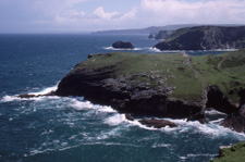
Although there is a lack of harbours continuing northwards, it is worth mentioning a few interesting rocks and headlands on the way up to the Bristol Channel. The coastline around Tintagel is notable because it is made up of old Devonian slate, which was extensively quarried until the mid 20th century for roofing purposes. The presence of slate, containing elements of copper, also explains the turquoise green water around this part of the coast. The Tintagel Cliffs is an SSSI area (site of special scientific interest). It includes Lye Rock where the barque Iota was driven against the cliffs. All but one of the crew was able to get onto the rock, from which they were rescued. Tintagel Castle is located on the peninsula of Tintagel Island. It has had a long association with the Arthurian legends and is thought to be the place of Arthur's conception. Today it is a popular tourist destination.
Further north is Hartland Point, a 99m high rocky outcrop on the northwest tip of the Devon coast. It marks the western limit of the Bristol Channel (on the English side) and was known by the Romans as the "promontory of Hercules". On the beach, just 400m from the lighthouse, can be seen the remains of the Dutch owned MS Johanna which was driven onto the rocks in a gale in 1982. Crossing Bideford Bay brings us to Baggy Point with its sandstone rocks and then Morte Point (meaning Death Point), a notorious site of many shipwrecks. In 1852 alone there were five ships wrecked in the area. One of the wrecked ships was carrying a cargo of live pigs, most of which actually survived. One is said to have lived off seaweed for a year and a small cove to the south of the point owes its name, Grunta Beach, to the pigs.
There seems little point in travelling further into the hazardous Bristol Channel with its strong high tides and dangerous shingle banks. A safer option is to strike out westwards for Lundy. Lying 19km off the coast of Devon, it is the largest island in the Bristol Channel and gives its name to the British sea area. It has been designated as a SSSI and was England's first Marine Nature Reserve and Marine Conservation Zone. It was on Lundy's southwest corner that the Royal Navy battleship HMS Montague came to grief in 1906, running aground near Shutter Rock, a high granite cliff. Thinking they were actually at Hartland Point on the mainland the captain sent a landing party ashore, where they encountered the keeper of the island's northern lighthouse. The same rock was the setting chosen by Charley Kingsley for the wrecking of a Spanish galleon in his historical novel Westward Ho. The present north and south lighthouses were built when the original was abandoned in 1897, due to complaints about the poor visibility of the light in fog.
Striking out approximately 60km northeast across the mouth of the Bristol Channel lies Worms Head, the first headland of our next leg of the journey up the coast of Wales.
Author - Dee White