The “hows, whys and wheres” behind the names.
Part 3. The Western Area – Lundy to South East Iceland
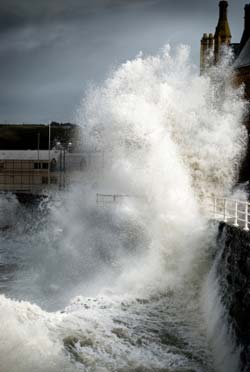
“Shannon, Rockall. Gale warning. North westerly gale force 8 expected later. Sea State moderate, becoming rough or very rough”.<
Lundy– the area named after an island in the Bristol Channel. In Norse the name is spelt “Lunde”. In 1924 the island was bought by an Englishman Martin Coles Harman who named himself king. Although the island had its own coinage it was never recognised as a sovereignty. A generation later his son lost the island in a wager of cards. The north and south lighthouses were built in 1897 and both were automated in 1991 and 1994.
Fastnet – the Fastnet rock is a rock island 6.5 miles to the south west of Cape Clear in SW Ireland – the most southerly point of the republic of Ireland. Its name comes from Old Norse meaning sharp tooth isle and in Irish it is called Carraign Aonair meaning solitary rock. It is used as the mid-point of one of the world’s classic offshore yachting races, the Fastnet Race, a 976k (608mile) round trip from Cowes to Plymouth. In the infamous race of 1979 severe storms wreaked havoc on the yachts taking part and resulted in the largest rescue operation in peace time. The current lighthouse is the 2nd to be built on the rock and is the highest in Ireland.
Irish Sea – obviously named after the area of sea between England and Ireland from St David’s Head to the Mull of Galloway. The majority of heavy goods trade from Northern Ireland and the Republic of Ireland uses this area and there are many ferry connections across the Irish Sea. During World War 1 the Irish Sea became known as U-boat Alley when U-boats moved from the Atlantic to the Irish Sea after the United States entered the war in 1917. It has been described as the most radioactively contaminated sea in the world due to the proximity of the nuclear instillation at Sellafield, although the Japanese seas may now take that accolade.
Shannon – takes its name from the river estuary of the longest river in Britain and Ireland. The River Shannon runs through 11 of Ireland’s counties and includes lakes such as Lough Allen, Lough Ree and Lough Derg. In the estuary is a historic lump of rock named Scattery Island. Though now uninhabited it has always been a holy place and according to legend was the home of a fearsome monster called Cathach. At one time there were seven monastic orders on the island until the Vikings arrived and killed most of the monks.
Rockall – an islet or rock stack in the North Atlantic Ocean thought to be the eroded core of an extinct volcano. It rises sheer to a height of approximately 21.4 metres and is regularly washed over by large waves in stormy weather. In January 1993 a record North Atlantic low pressure of 914 mb was recorded: “Rockall, Malin, Hebrides, Bailey. Southwest hurricane force 12 or more”. The area is an extremely fertile fishing ground and in the 1860’s became popular with trawlers. As the volume of shipping increased so did the risks. One of the worst accidents was when the three-thousand-ton liner Norge struck the reef en route from Copenhagen to New York. The seas were so rough that nearly half of the Norge’s lifeboats were smashed and 600 people drowned.
Malin – named after Malin Head on the Inishowen Peninsula, the most northerly headland on the mainland of Ireland and covering half of what used to be the area Hebrides. The existing lighthouse began service in 1958. It is 23 metres tall to the balcony and has a lantern of 19 feet tall. It was converted to solar power in 2000.
Hebrides - the area around the beautiful islands of the Hebrides, off the northwest coast of Scotland. There are two main groups: the Inner and the Outer Hebrides separated by the strait known as The Minch in the north and the Sea of the Hebrides in the south. The Isle of Barra was the filming location of the classic comedy “Whisky Galore”. The Outer Hebrides have long been used for an allegory for somewhere remote and cut off from civilisation.
Bailey – a sandbank in the North Atlantic Ocean, between Scotland and Ireland. It is a completely seabound area and seemingly has no interesting features, unless someone knows better!
Fairisle – the area around the island between Orkney and Shetland and originally divided into two area and named after these two groups of islands. It is the most remote inhabited island in the UK. In 1588, the flagship of the Spanish Armada, El Gran Grifon was shipwrecked in the cove of Stroms Heelor. The 300 sailors on board had to spend 6 weeks living with the islanders. The wreck was not discovered until 1970. Fair Isle is served by its own ferry which traverses one of the roughest crossings in Europe.
Faeroes – named after the string of craggy Faeroe Islands between Scotland and Iceland. According to legend they were created when God cleaned out his finger nails after creating the earth. They are inhabited by 50,000 descendants of the Vikings. For more than 1000 years the people here have hunted pilot whales and whale meat continues to be an important part of their diet. The islands lie in the path of depressions moving northeast and bringing strong winds and heavy rain at all times of the year.
SE Iceland - an area of the Atlantic, as its name suggests, not surprisingly, south east of Iceland. It has one of the longest coastlines of any shipping forecast area. When severe winter cold combines with strong winds and a cold sea, “icing” can occur. This phenomenon normally only happens in SE Iceland. If expected, icing warnings (light, moderate or severe) are given as the last item of each sea area forecast.
This is part 3 of a 3 part article. Parts 1 and 2 can be read here: