The “hows, whys and wheres” behind the names
Part 2. The Southern Area – Dover to Sole
“Wight, Portland, Plymouth. Wind southwest 4 or 5, increasing 5 to 7. Occasional rain. Good occasionally poor”.
Dover - named after the town and the Dover Strait which is the narrowest part of the English Channel. The shortest distance across the strait is 34 kilometres or 24 miles. If the visibility is good it is possible to see from Dover to Cap Gris Nez near Calais with the naked eye. The strait is one of the busiest international seaways in the world being used by over 400 commercial vessels each day. This has resulted in a 24 hour watch by HM Coastguard and the enforcement of strict shipping lanes.
Wight – the area takes its name from the island which some believe gained its name from the chalk located there. However the first known people to inhabit there back in 1900 B.C. called it “With”. Famous for its beauty and wildlife, it is also known world wide as a centre for sailing. It plays host to several racing regattas, notably Cowes Week and also hosts The Fasnet race, the Round the Island Race and the Commodore’s Cup. To sailors the island is synonymous with The Needles, a row of three distinctive stacks of chalk off the western extremity of the island.
Portland – named after the area which is almost an island 5 miles south of Weymouth. Portland harbour is one of the largest man-made harbours in the world. It was a Royal Navy base and played important roles in the First and Second World Wars. The lighthouse on Portland Bill is a vital landmark for ships passing the headland and its tidal race. Portland Ledge (the Shambles) is an underwater extension of Portland Stone into the English Channel. It disrupts the tidal flow and causes a race (Portland Race) to the south of Portland Bill. Fourteen ships were lost there one stormy night in 1901 – 10 years before the Shipping Forecast was first broadcast. The current only stops for brief periods in the tidal cycle and in spring tide of 2 metres it can reach 4 metres per second, approximately 8 knots.
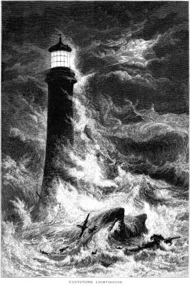
Plymouth – takes its name from the city on the coast of Devon which is linked inevitably with Sir Francis Drake. It was from this port that he embarked on his privateering exploits to Spain and from here too that the British fleet, with him as Vice Admiral, set out to confront the Spanish ships of the Armada in 1588. Its River Tamar marks the border between Devon and Cornwall and together with the River Plym flows into the natural harbour of Plymouth Sound used by large commercial vessels, ferries, fishing vessels and many amateur boatmen. The city has the largest operational naval base in Western Europe and ferry links to France and Spain. The famous lighthouse the “Eddystone” stands 9 miles south west of Rame Head. The current one is the 4th and was designed by James Douglas and first lit in 1882. It replaced the celebrated Smeaton’s tower of 1756. John Smeaton modelled it on the shape of an oak tree and built it of granite blocks. It was only replaced when the rocks beneath it began to erode causing the tower to shake. The foundations proved too strong to be removed and the stub of Smeaton’s Tower can still be seen.
Biscay – named after the Bay of Biscay, the area to the west of France which is a gulf of the northeast Atlantic Ocean. The area is feared by many yachtsmen due to its legendary reputation. It is prone to depressions which can cause severe weather at sea. If the pressure falls rapidly powerful windstorms can be generated which travel along the Gulf Steam at great speed. The waves are whipped up as the Atlantic rollers hit the Continental Shelf and “the bottom gets too close to the top” leaving the waves nowhere to go except to build up and topple over on themselves. In the days of the square riggers, ships were unable to make way to windward and having been driven into the Bay by westerly storms they were often unable to get out again and were in danger of being wrecked on a lee shore. The sailors in the last Global Challenge Race of 2004 were told to keep well out of the Bay in stormy weather. However many of the fleet were driven in, beating against the wind. Fortunately with a cutter rig they could dig themselves out again. When heavy storms blow up some ports can become dangerous to enter or even inaccessible.
Trafalgar – named after the headland Cape Trafalgar in Southern Spain. The naval battle bearing the same name was in 1805 when the Royal Navy destroyed Napoleon’s combined French and Spanish fleet. The light from the 34 metre high lighthouse, built in 1860, can be seen for 22 miles. It is the only area not to feature in every broadcast.
Fitzroy – used to be called Finisterre but in 2002 it was changed to honour the man who created the Shipping Forecast. Robert FitzRoy had a distinguished career. He was a pioneering meteorologist as well as a surveyor and hydrographer. He was the pilot of HMS Beagle which was to carry Charles Darwin on his notable voyage. He later became governor of New Zealand. After he was recalled back to England he created the chart of sea areas now known as the Shipping Forecast, which allowed weather predictions to be made. At that time there were only 13 zones which have now grown to 31. Sadly financial concerns, failing health and his struggle with depression took their toll and in 1865 Vice Admiral FitzRoy committed suicide. This is the only sea area to be named after a person.
Sole – is named after two sandbanks, the Great and Little Sole Banks to the west of the Isles of Scilly in the Atlantic Ocean, but the area has no land boundary. The Sole Banks are defined for fishery protection purposes. The Scillies themselves consist of 55 separate islands of which 5 are inhabited, roughly 28 miles from Lands End. The famous Scillonion ferry takes up to three hours from Penzance. There have been a large number of wrecks around the coasts of the Isles which in the past were looked on as a blessing in disguise by the Scillonions. Their spilled cargoes were useful bounty when communications were not as good as they are today, and “wrecking” was an essential part of island life.
Read part 3 of this article: Sea Areas of the Shipping Forecast - Part 3