There are some weird buildings and structures around our coasts, sitting on prominent points and headlines, seemingly with no obvious purpose. Non boating types may imagine them to be follies built by some wealthy landowner so that people will remember him when he is long gone. Others may scratch their heads and ponder the use of such strange structures. The large blotches of paint on prominent rocks or walls may be put down to some sort of graffiti.
Actually these all have had a very significant importance in coastal navigation. They are called Daymarks or Leading Lights. Many are now redundant but linger on as bizarre landmarks in recognition of a region’s maritime heritage.
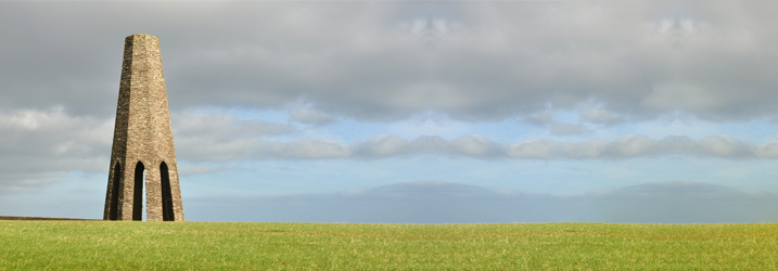
Daymarks are usually structures built intentionally to aid sailors navigating featureless coasts or to guide them into a well-hidden harbour. Daymarks come in a variety of conspicuous forms, from grand obelisks and pyramids to colourful cone-shaped structures. A few resemble traditional lighthouses. They will often be found on a prominent hill or headland, such as the Daymark known as the Pepper Pot just east of the entrance to Dartmouth harbour in Devon, UK. It is one of the most impressive on the UK coastline. Built in 1864, it is 25-30 metres in height, six sided and certainly looks more like a quirky folly than a navigational aid.
By Nilfanion [CC BY-SA 4.0 (https://creativecommons.org/licenses/by-sa/4.0)], from Wikimedia Commons
Sometimes existing buildings are painted so that they stand out and can be seen easily by those on the water, such as the one in L’Aberwrach in Brittany, France.
Two separate features, such as painted rocks or purpose built structures, separated in distance and elevation may be used to indicate a safe channel. When these are aligned with one above the other, they provide a bearing. If the vessel is on an incorrect course, the features will not align.
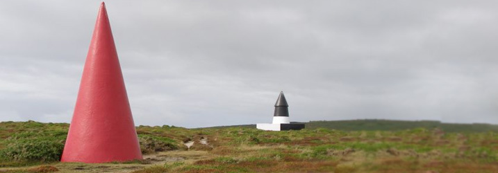
Jim Champion / Navigation markers on Gwennap Head
These two structures on Stepper Point above Porthgwarra Cove, in Cornwall, UK, were built on a headland 240 feet above sea level and are visible from 30 miles away. When it was built in 1830, the Daymark cost £29 and the money was raised by giving donors voting rights in the Harbour Association. One Guinea would buy one vote. The Georgian Daymark was built there to warn vessels of the Runnel Stone, a treacherous offshore pinnacle of rock. In this case, the black and white cone should always be kept in sight. If it becomes masked by the red cone the vessel would be virtually on top of the Runnel Stone. Nowadays it is marked by a buoy emitting an eerie moaning sound.
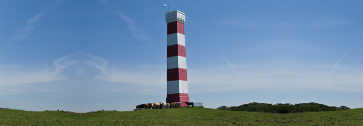
This Daymark at St Martin’s, Isles of Scilly, built in 1683, is the earliest dated example in the British Isles and like the secluded cairns around it, the Daymark is now a Scheduled Ancient Monument. Measuring 16 feet wide and 36 feet high it is built of rendered granite. Over the years it has been painted in different ways but took on its current striped appearance sometime after 1833. On a clear day it can be seen from the Cornish Coast.
Jim Champion [CC BY-SA 2.0 (https://creativecommons.org/licenses/by-sa/2.0)], via Wikimedia Commons
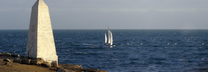
This Grade II listed Trinity House Obelisk dates back to 1844 and was erected at Portland Bill in Dorset, UK, to warn mariners of the rocks just off the headland. These had claimed their fair share of vessels over the centuries. The 7 metre tall Daymark was almost lost in 2002 when Trinity House debated whether it was too expensive to maintain as a historic navigation marker. Fortunately it was preserved and still stands proud above the waters of the English Channel.
Lisa Jarvis / Emmanuel Head
This pyramid shaped navigation marker on Emmanuel Head on Holy Island in Northumberland, UK, is understood to be the earliest navigation marker on the east coast. It was built between 1801 and 1810 to safeguard shipping off the Northumberland coast. Around the same time, two further beacons were constructed at Guile Point to help sailors navigating the treacherous approach to the small harbour. They are East Old Law and West Old Law, 70 feet and 83 feet tall respectively and are spaced 122 yards apart. The towers once had iron triangles on their tops which have since become lost, but West Old Law now has a fixed light a third of the way up its structure. Beware of using these as navigation aids today as they are an example of altered channels due to changing tides and currents.
By Nilfanion (Wikimedia UK) [CC BY-SA 4.0 (https://creativecommons.org/licenses/by-sa/4.0)], via Wikimedia Commons
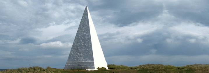
The striped Gribbin Headland Daymark is unusual in that it can be climbed by means of a 109 step internal staircase. It towers 26 metres above the Cornish headland and was built by Trinity House in 1832 to pinpoint the approach to Fowey’s narrow and rocky harbour entrance. It helped ensure that sailors did not mistake the treacherous shallows of St Austell Bay for the deep waters of Falmouth harbour.
Leading Lights, also known as Range lights in the US, are a pair of light beacons used in navigation to indicate a safe passage for vessels entering a shallow or dangerous channel; they may also be used for position fixing. The beacons consist of two lights that are separated in the same way as the Daymarks described above, coming into alignment when the vessel is on the correct course. These are often illuminated day and night. In some cases the two beacons are unlit, in which case they are known as a range in the US or a transit in the UK. These beacons may be artificial or natural. During the day, the lights may not be easily seen so Leading Lights may be fitted with secondary visual aids such as prominent flags, or the structures may be painted to make them stand out.
Some major rivers, such as the Elbe in Germany, have a series of Leading Lights which the navigator will line up each time he needs to make a turn. This provides guidance from Hamburg to the sea.
Modern markers may not be as architecturally interesting or impressive as the historic Daymarks but they still serve a useful purpose, such as these Bas Obispo Northbound Range Lights, lighted stripes on open steel structures marking many of the shorter ranges on the Panama Canal.
Leading Lights were used in England as early as 1763 to mark the Port of Liverpool and the first set of Range lights in the US were privately set up by subscription at Newbury port Harbor in Massachusetts in 1788.
Leading Lights are sometimes designed to be movable, allowing their position to be changed in the event of a safe channel altering course. These include one at Hilton Head, South Carolina, the original Chatham Light and the Nantucket Beacon which was eventually replaced by the Nantucket Range Lights.
Nowadays, with electronic charts and GPS, many Daymarks and Leading Lights have become virtually redundant. But even so, electronics can sometimes fail or become unreliable. I have sailed along several narrow creeks in plenty of water while my chart is showing me halfway up the bank. Substantial towers perched on a headline are wonderful landmarks to aim for and I really feel that our coastlines would be all the poorer without them.